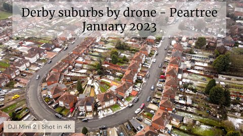
Pear tree, Derby. Part of the Derby suburbs by drone series | 4K
18 View
Share this Video
- Publish Date:
- January 23, 2023
- Category:
- Drone Videos
- Video License
- Standard License
- Imported From:
- Youtube

This little drone video is a flight over the Derby suburb of Pear tree (Peartree)
Pear Tree's most famous landmark was the Baseball Ground, home of Derby County football club, it was demolished in 2004.
As well as this drone flight Ive captured the area from 400ft high in high resolution 360 degree photography :
Link to my high resolution 360 degree photograph on Google Maps :
400ft above Peartree, Derby :
https://goo.gl/maps/MAggS6LJNXzBLX1V9
► Please like, Share, subscribe and turn on notifications.
Feel free to share the link to Facebook, Twitter or to anyone you think would like to see it.
Best viewed on a large computer screen or smart TV as this is recorded in 4K resolution with great music so a real waste watching it on a small phone screen. Did you know you can cast it to your smart tv from the YouTube app?
-------------------------------------------------------------------------------------------------------------------------
Music Credits :
'Goliath' [Epic Orchestral CC-BY] - Scott Buckley
https://youtu.be/qYTJ8hDj_Hc
-------------------------------------------------------------------------------------------------------------------------
Information on my drone flying :
● My drone is a Class C0 drone sub-250g type, because its such a lightweight drone (236g), I'm allowed to fly it over residential and commercial property and people (but not crowds) without permission.
● I passed the theory test and have both valid flyer ID and Operator ID's.
● I have drone insurance (£5 million public liability insurance cover).
● I strictly follow all the CAA guidelines on flying my drone.
● I always fly in Cinematic mode (slow speed) as this is safer in urban environments.
● I plan all of my flights in advance of taking off to ensure I know my complete flight path and am aware of any obstacles in the way.
● In order to maintain VLOS (visual line of sight) with my drone I use extremely bright Strobe lights, if there are trees or buildings in my way then I have to land and carry on from a different location this means that I often have to join bits of flights together, I try and line up edits using telemetry to match altitude and position etc. but its not always possible to get good joins in clips so this can mean jump cuts and fades between clips.
● I carry out a risk assessment before each flight and ensure all batteries fully charged, GPS has a good fix etc.
● I always engage with anyone nearby informing them the reason for my flight.
Thanks
Andy
#DJIMini2 #Derbyshire #Drone #Derby
--------------
By: comedyhunter
Title: Pear tree, Derby. Part of the Derby suburbs by drone series | 4K
Sourced From: www.youtube.com/watch?v=V5tV6mAXAvs
Check out the 3 most popular drones on Amazon while they're on sale


